The plan of the route is shown above on an extract from OS Maps. Click this link to the Platinum Route marked up on OSMaps
To return to the event Home page Click this link www.threepeakstrial.co.uk
The plan of the route is shown above on an extract from OS Maps. Click this link to the Platinum Route marked up on OSMaps
To return to the event Home page Click this link www.threepeakstrial.co.uk
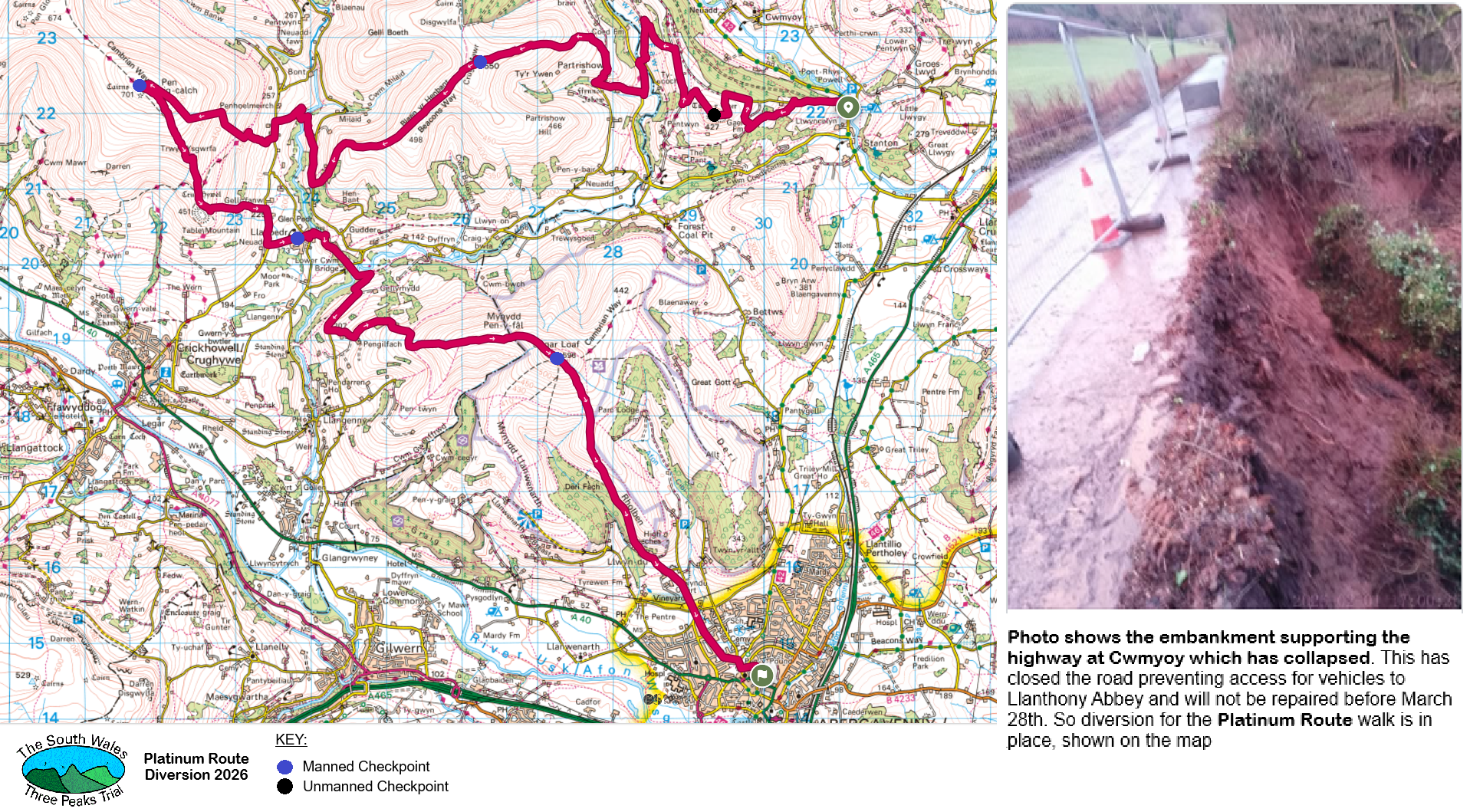
Platinum Route: 20/2/2026 UPDATE: Normally this linear walk of about 17 miles and 5000' of ascent goes from Llanthony Abbey to Abergavenny over Bal Mawr, Pen Cerrig Calch and Sugar Loaf. However an embankment supporting the road to the Llanthony Abbey drop-off point has collapsed closing the road.
Monmouthshire Council
have confirmed the road will not reopen before the 28th March. Therefore the drop-off point is changed to the Queens Head near Stanton (GR 311222) and the first manned Checkpoint at Bal Mawr (GR 267271) is changed to Crug Mawr (GR 262226). The revised route is shown on the map above.
For a more detailed, marked up map using the Ordnance Survey
OSMaps website
![]()
The road north of the village of Stanton near Llanvihangel Crucorney is closed due to a landslip. Unfortunately this means the bus for walkers on the Platinum Route cannot access the Llanthony Abbey drop-off point. This requires us to have a new start point and a route amendment. So the bus will drop off near the Queen’s Head just North of the village of Stanton (Grid Ref. 311222). There is now an unmanned Checkpoint on Gaer (Grid Ref. 294219) and the Bal Mawr checkpoint is moved to Crug Mawr (Grid Ref. 262226). The diversion is shown on the map screenshot below. Apologies for any inconvenience this may cause.
A suggested route is as follows:
The start point of the walk is now near the Queen's Head just North of the village of Stanton (Grid Ref. 311222). Take the minor road heading east uphill towards Penrhiw farm. The road surfacing is generally poor and broken up in a lot of places. Eventually the track becomes unmade shortly before you reach a gate at GR295223. Go through the gate and turn sharp left (south), keep the boundary wall on your left and go uphill.
At the brow of the hill and before the path begins to descend, just before two small trees on the left (one either side of the fence) turn right onto the path to the summit of Gaer.
At the summit is a Cairn with the unmanned Gaer Checkpoint 1 (GR 294219). Note the letter on your Checkpoint Card (bring a pencil).
From the summit follow the grassy path in a northerly direction with a zig-zagging stone boundary wall to your left. If the weather is ok, you should be able to see a phone mast ahead which is near the top of the ridge and to the right. You need to head towards this keeping to the path on the top of the ridge. Shortly after the phone mast, keep to the path near the stone boundary wall on the left side of the ridge (marked as 'Cambrian Way' on the 1:25000 OS map) and, just after a break in the stone boundary wall, drop down to a gate at GR 288227 (it was by a field of daffodils during the reccie in mid- March, so they may still be there).
Go through the gate and you'll be on a path with a stone wall on your left and a fence on the right. Follow the path and don't cross any stiles or gates you pass and you eventually reach a gate. Go through the gate and after a few hundred metres you come out onto a tarmac road by Ty mawr farmhouse. Turn left and follow the road.
You reach a converted chapel with a graveyard by a river bridge. Cross the bridge. Continue on the road for approximately 100m to a road junction. Cross over the road and follow the path opposite marked 'BeaconsWay'. Continue along the Beacons Way passing a ruined building on the left then through 2 fields with gate openings then turn Left towards a white farmhouse, (Ty'n y Llwyn Farm) to reach a gate. Go through the gate and walk on the track in front of the white farmhouse, then just after the track curves sharply right to another gate. After 200m the stone wall on the right ends and just after this the track splits left (flat path towards chapel) or straight on uphill. Take the left path to Partrishow church (Grade 1 listed dating to 1060). Walk through the churchyard path to the road. Turn right and keep on the road, passing a stone building and finger post with a style on the right. Continue on the road until you reach a finger post to Crug Mawr 'Bridleway'.
Bear left off the road onto the bridleway and follow the bridleway to a gate then a second gate a short distance away. Cross through both gates and go left, uphill to the Crug Mawr Checkpoint 2 (GR 262226) .
After the checkpoint follow the Beacons Way to rejoin the usual Platinum Route to the trig point and cairn on Pen Cerrig-calch (Checkpoint 3 GR 217224).
Retrace your steps south-east and follow the main path down to Table Mountain and then east down to Perth-y-pia (GR 230207) then the road down to Llanbedr.
Fourth Checkpoint is in Llanbedr at the church (GR 240204). Water is available at this checkpoint. From the church go down the lane to the river. Cross to the other side and head south-east, passing a second bridge, then straight on to Lower Cwm Bridge (grid ref. 245199). Go straight over the road to field and footbridge. When you reach the lane go right and up (muddy) – follow this until you reach the tarmac road – turn right onto this. After about ⅓ mile take the left road up then follow the bridleway for Sugar Loaf. When you reach open ground take the right path, skirting the wall on your right, then go left and just keep going up the ridge.
Fifth Checkpoint at summit of Sugar Loaf GR 273188. From here head south-south-east towards Rholben. At grid ref. 277176, take the right fork in the path which will take you down through trees towards St Marys Vale. Stay on this main path until you hit the road which goes towards Home Farm (grid ref. 287159) then Abergavenny.
Final Checkpoint – Check in first at the Scout Hall, Abergavenny (GR 299146) then go next door for refreshments in the Guide Hall.